sown on stony ground is a space for me to explore biogeoengineering and the use of modelling to evaluate its climate change mitigation potential. Desert greening – past, present and future – is the principal theme, although it touches on wider issues in afforestation, land management and the carbon market.

Monday, 30 November 2015

COP21: Forests for sale?

Global policy on the future of the Earth's climate might be decided this week, if we're lucky enough. World leaders, policy-makers, journalists and observers all descended this morning on Le Bourget, a banlieue of Paris, to participate in the 21st UN Climate Conference with a stated objective to achieve:
a legally binding and universal agreement on climate, with the aim of keeping global warming below 2°C.
Hopes are high that this conference will be The One. Ed Milliband wrote that COP21 "can save the planet" and today Barack Obama recognised it as a "turning point". If you take even a casual interest in environmental issues, then I don't I need to explain why it is so important that the global community come to a firm consensus on how to best steer our planet away from dangerous climate change.

The bulk of today's session involved world leaders presenting to the world their positions, objectives and commitments with regards to climate change. While there were was no shortage of rousing and impassioned speeches, it is the start of the Lima–Paris Action Agenda Focus on Forests session tomorrow which is of particular interest to me personally, given the topic of this blog. At last year's conference in Peru, fourteen highly-forested developing countries issued a challenge to developed nations to kindle and develop financial partnerships in order to meet emission reduction targets with the use of forest carbon. In essence, the Lima Challenge is a call for greater recognition — and therefore, possibly, exploitation — of the economic value locked up in billions of carbon-stocking trees. Something in me questions the wisdom of this kind of thinking — see this article for an excellent case study of the limited success of REDD+ in Papua New Guinea.

Questionable effectiveness is not my only opposition to such schemes: that Earth's great expanses of green forest can be reduced to their mere economic value is an idea which is morally troubling to me (this might seem funny, if you like, considering I'm studying Environmental Modelling). However, I recognise that this may seem like a rather cynical way of looking at things, and I'd be interested to hear your general opinions on forestry-based carbon trading initiatives. As developing countries increasingly push for the economic valuation of their forests as a marketable resource, how much importance do you think should be placed on biodiversity, or any intangible value inherent to forest life? The session tomorrow morning will be introduced by Prince Charles; Ségolène Royale, the French Minister of Ecology, Sustainable Development and Energy; and Manuel Pulgar-Vidal, the Peruvian  Minister of Environment. As they set the tone for the day's discourse, I hope that, among all the talk of business commitments, emission reduction partnerships and low-carbon development strategies, somebody will find the time to see the forest for more than just the cash growing on its trees.

Saturday, 21 November 2015

Green Sahara: how? pt.2 — Model not so good

In my most recent post I outlined how atmosphere circulation models were used to develop a mechanistic understanding of how the climate system is able to would be able to produce a green Sahara in the mid-Holocene. However, there are several important issues with these modelling experiments that need to be discussed.

Modelled mid-Holocene precipitation anomaly
Reproduced from Kutzbach & Guetter (1986
As this image shows, the low spatial resolutions of these early models mean that one grid cell represents a large area of the continent. When combined with relatively sparse spatial coverage of the observation sites, the difficulty in the evaluating the extent of monsoon penetration into the Sahara with any great degree of precision is apparent. More detailed palaeoclimatic maps were developed over the course of time, against which models of increasing resolution could be assessed. These datasets proved key to the first phase of the Paleoclimate Model Intercomparison Project (PMIP); a collection of experiments established in the 1990s in order to evaluate the ability of eighteen different AGCMs to reproduce African Humid Period state when run with 6 ka parameters and boundary conditions. The project found considerable agreement in results between the different experiments, but that "the magnitude of the monsoon increases over northern Africa are underestimated by all the models". This reveals one of the most significant weaknesses of such complex models: the comprehensive inclusion of complex processes is restrained by the available processing power of the computers they run on. AGCMs — as the term implies — simulate atmosphere dynamics only. Other constituents of the Earth system, such as the ocean or the ice sheets, must be either prescribed or omitted.

Following the somewhat dissatisfying results of PMIP Phase 1, however, the palaeoclimate modelling community took advantage of ever-increasing computational resources to run more complex experiments, and at higher resolutions, to more success. For example, one experiment found that, when the land surface scheme is prescribed to be more representative of a vegetated Sahara, the 6 ka WAM reaches further northward and is considerably enhanced. This implies that the simulation of land surface–atmosphere feedbacks would be important in getting a more realistic monsoon, and indeed that assertion was supported by the improved results of models which included interactive soil moisture, snow or vegetation components. Nevertheless, it became apparent that the realism of these experiments was to a degree limited by the fact that they simulated atmosphere circulation only, as it was likely that the ocean also had a part to play in intensifying the mid-Holocene monsoon.

6 ka WAM precipitation reachers further northwards with a full AOGCM (dashed line) than with prescribed SSTs (dotted line). Solid line is control experiment. Reproduced from Braconnot et al (2000)
Indeed, Kuztbach and Liu (1997) found better agreement with observations when an AGCM is asynchronously coupled to an ocean general circulation model (OGCM); by allowing the two dynamic systems to interact, atmosphere–ocean feedbacks — which had already been theorised from contemporary observations — could be simulated. With the use of this class of model it was ascertained that the strength and even direction of this feedback varied between regions; dampening monsoon rainfall in Asia while intensifying the West African Monsoon. More components could be added to provide a more nuanced understanding of the interplay between different parts of the climate system. For example, asynchronous coupling of an AOGCM to the BIOME vegetation model revealed that atmosphere-ocean feedbacks are the primary control of the flux of warm oceanic air onto land, while retention of this moisture on the continent is stabilised largely by land surface–atmosphere feedbacks. Including vegetation is therefore key to maintaining an amplified monsoon. Nevertheless, fully synchronised AOGCMs were unable to adequately simulate the rainfall conditions in the northern Sahara indicated by palaeodata, even with a dynamic vegetation and more explicit treatment of soil characteristics.

In a general sense, incorporating more components in a modelled experiment allows a wider range of climate processes to be simulated, and interact with each other, producing a stronger monsoon. However, similarly complex models can vary widely in their results, as shown in the image below reproduced from a study comparing two AOVGCMs whose atmosphere core differs.

6 ka precipitation anomaly from ECHAM and LMD models, initialised with present day (left) and green Sahara (right) vegetation. It is clear that there is much greater monsoon penetration using ECHAM.
The key takeaway from this is that the degree to which the mid-Holocene WAM is intensified by inclusion of vegetation is strongly dependent on any given model's treatment of atmospheric circulation dynamics. The same conclusion emerged at the conclusion of the second phase of the PMIP, which also found that model results vary not only in their response to mid-Holocene forcing, but also to modern forcing.
"Model biases or differences between the control experiments need to be considered to understand the response of various models"
Since much of the variation in the results the model experiments discussed here is due to uncertainty in their parameterisation of real life physics (as observed today), it is very difficult to assess how representative the modelled mechanisms are of the true climatic processes that generated the green Sahara.

None of the PMIP Phase 2 studies successfully reproduced the observed AHP conditions. It appears that thus far, even with the inclusion of oceans, vegetation, and soil, there is something in climate models which makes them too restrained in their simulations of the mid-Holocene monsoon. I'm not yet sure why. It is possible that there is some conservative bias inherent to the operation of all GCMs. Alternatively, there may still be some monsoon-intensifying mechanisms which are as-yet unknown or otherwise incompletely modelled. The next PMIP phase will involve the use of ESMs, a class of model which incorporate a far more comprehensive range of Earth System components, and therefore climatic processes, than previous generations of models.

It is worth pointing out that Moore's law may not hold much longer. I don't say this to imply that climate models will be approaching some kind of peak complexity any time soon, but rather because it's relevant to my doubts about a particular line of thinking in modelling. I'm not sure whether the best way to tackle model–data disagreement over the green Sahara is simply to chuck more computing power at the problem. That said, I don't yet have any truly valid reason to be sceptical. Either way, I think it's worth getting to the root of the issue. To extend a concept that my coursemate Damian highlighted, climate modelling involves "experience and intuition": not only to understand why models work, but also why they don't work. I guess gaining such experience is a key part of undertaking this blog.

Thursday, 12 November 2015

Green Sahara: how? pt.1 — Model good

If you haven't yet, read this post to find out what "green Sahara" means.

The Sahara, a place that we know to be a near-lifeless expanse of hot desert, was once a humid and highly vegetated environment? Only six thousand years ago? How could this be? I know, reader: the information in my last post shattered your reality. Please pull it back together, and make yourself a nice cup of tea. In this post I'm going to outline the natural processes that drive North Africa to flip between green and desert states, and discuss how humans have used modelling to understand these mechanisms.

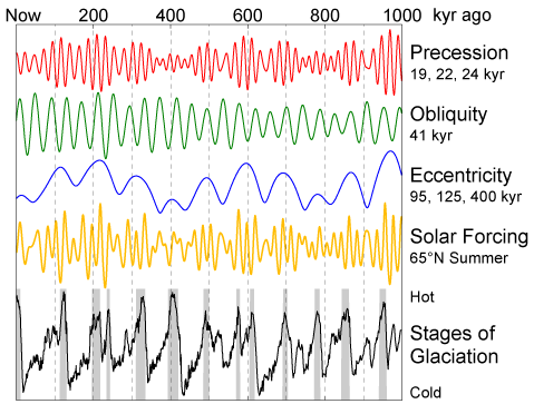
At the heart of this issue is Milankovitch theory, named after the Serbian astrophysicist who developed it in the early 20th century. It holds that the Earth's orbital parameters have cycles of variation which determine not only the amount of solar radiation Earth receives, but also the spatial and temporal distribution of this energy (if you want a refresher, click here and here for an excellent, in-depth primer). Their combined rhythm is what drives many of our planet's climatic trends on a long term basis.

The pacing of the Earth's glaciation cycles by the Milankovitch cycles.
In the image above you can see that the approximately 100 ky cycles of the Quaternary glaciations appear to be paced by eccentricity. However, of the three orbital forcing components, it is 20 ky precessional signal which has the most dominant influence on the state of Sahara. Land surfaces heat up more quickly under summer insolation than the ocean, and the resultant atmospheric pressure difference drives moist marine air over the African continent, where it rises and cools to produce the rainfall that we call a monsoon. Land warming is increased when the perihelion is closest to the boreal summer, and the combined effect of the 9 ka orbital configuration is a ~6% higher monsoon season insolation over northern Africa compared to today. The resultant increase in the land-sea thermal contrast intensifies the West African monsoon, bringing this seasonal precipitation deeper and more northwards into Africa and painting the Sahara green with life — or so goes the theory.

When evidence for the green Sahara was first emerging, atmosphere general circulation models (AGCMs) were used to explore the effect of mid-Holocene orbital forcing on climate in North Africa. Since these models could be run repeatedly with minor changes, they were used to determine the sensitivity of the results to orbital parameters and to changes in boundary conditions (such as sea surface temperatures and the ice sheet configuration), and the experiments were were largely successful in simulating the degree of rainfall intensification suggested by the paleoclimatic evidence. One model's increase in mid-Holocene monsoon wetness in North Africa (approximately 0  30 °N) compared to modern can be seen below.

Modelled latitudinally-averaged precipitation – evaporation anomaly (9ka – 0ka). Dashed line shows results of a run which prescribed a North American ice sheet. Reproduced from Kutzbach & Otto-Bliesner (1982)
By showing that the monsoon trend was representative of an overall northward shift of the inter-tropical convergence zone (ITCZ), these experiments improved the mechanistic understanding of the processes in the context of large-scale atmospheric circulation. AGCMs were therefore very useful in confirming the primacy of the Milankovitch cycles in modulating rainfall conditions over northern Africa. They also showed that the influence of on climate is considerably weaker in the tropics than in higher latitudes, as shown in the graph above.

By the end of the 1980s, it seemed like climate models forced by mid-Holocene conditions were able provide a fairly "realistic" simulation of a green Sahara, reaffirming the theories —  developed more than half a century previously — of the control of long term climate by insolation cycles. In the my next post I'll expand on why the initial understanding of the green Sahara described here isn't quite as rosy as it seemed.

Thursday, 5 November 2015

Green Sahara: wait, what?


52 days? That is indeed a long, long way.
Credit: Basil Pao @ www.palintravels.com
Last night I happened to catch my parents enjoying an ageing Python slinking his way across North Africa (a recommended watch), and I was struck by Michael Palin's phrasing:
We're now into what my French guidebook calls desert absolu: absolute desert. The earth stripped clean. As bare as a glacier, as featureless as the sea.
If I asked you to describe what you associate with the word "Sahara", I'd hazard a guess that you'd paint a picture of an incredibly arid environment; maybe endless rocky plains or an expanse of rolling sand dunes only occasionally punctuated by a clutch of palm trees around an oasis. However if I could travel back six thousand years ago to the mid-Holocene and ask the same question to a human living in the region, the response would be very different.

Kakum National Park, Ghana
Credit: Eleftherios Siamopoulos
Water is the key to life, and the above photo shows the vivifying effects of the West African monsoon (WAM). I'm using it here to provide an indication of what a typical Saharan landscape may have looked like to somebody living there during what is known as the African Humid Period (AHP, ~11.5 – 5.5 ka). Though it may seem fanciful, the idea that heavy monsoon rains extended deep into northern Africa, sustaining a lush and verdant terrain criss-crossed by a network of lakes, marshes and wetland ecosystems, is supported by many lines of proxy evidence:
Paleomegalakes of the Sahara outlined in white (reproduced from Drake & Bristow (2006))
This mid-Holocene green Sahara was no one-off freak occurrence, either. On the contrary there were repeated northward shifts in the monsoon position over the Quaternary Period, resulting in alternating phases of humidity and aridity in North Africa as inferred from lucustrine and marine sedimentary records.

It's therefore evident that the image we have of the Sahara is one very specific to how we know it to be today. That may seem like a truism, but I believe it's important to stress that the environment around us can change rapidly on a continent-wide scale, and has dramatically done so in the recent past. In the context of ongoing climate change, the motivation to understand how the Sahara is able to change states so dramatically should be clear. If this interests you as much as it does me, then you'll be delighted to find that this is topic of my next post.